 Chilly drizzle gaining momentum this Friday morning on California’s north coast. Supposedly, a goodly-rain storm about to sweep in from the south, and the outside looks very much like it.
Maybe two-to-four inches for us along the shoreline, could bring up to seven-inches in the eastward mountains.
Even with our current ‘conveyor-belt’ rainstorms, this El Niño-influenced rainy season won’t solve California’s drought catastrophe, and the problem isn’t just about rain/snow — from McClatchy yesterday: ‘“Not all water demands are going to be met, 100 percent, by the recovery we’re seeing relative to the last four years,” NOAA research meteorologist Martin Hoerling said Wednesday in a news briefing. “There are systemic issues with water supply that go beyond precipitation in any given year.”‘
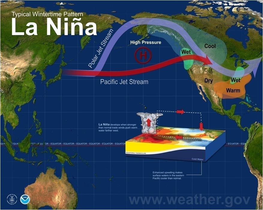
And how about La Niña, the dry sister?
(Illustration: ‘Rain,’ by Brad Sharp, found here).
Although the rain/snow greatly helped the dry conditions, still wasn’t enough to rectify five years of drought. An added glitch was February’s huge beautiful-weather gap in the winter system, erasing some gains.
The NOAA’s assessment went beyond weather — highpoints from the McClatchy piece:
Joined by several NOAA colleagues, Hoerling briefed reporters on the latest research into the real-world laboratory conditions spun up by El Niño.
For scientists and lawmakers alike, it’s a mixed bag.
El Nino is a cyclical weather pattern associated with a zone of warm water that develops in the Pacific Ocean.
Its counterpart, La Nina, is associated with a band of unusually cold Pacific Ocean water.
Precipitation is way up this year, exceeding 100 percent of the average at measuring sites in places such as Placerville, Mariposa County’s Exchequer Dam and the Tulare County town of Lemon Cove, among other locations.
The Sierra Nevada’s snowpack is consequently much better than in recent years, but still below average and vulnerable to early melting.
Depleted groundwater is unlikely to fully rebound.
Enhanced river flows will help salmon that require cold water, but other factors still threaten fish health.
“Not all drought conditions are going to recover, regardless of how much additional (precipitation) we get,” Hoerling said.
Statewide, the Sierra snow water equivalent as of Wednesday was 83 percent of normal for this time of year.
The snowpack is deepest in the central Sierra Nevada, where it is 87 percent of average, and slightest in the southern part of the mountain range, where it is 78 percent of average.
Another added bonus is the possibility of an anti-El Niño — this morning via The Weather Channel:
El Niño is forecast to weaken through the spring with conditions in the equatorial Pacific Ocean potentially transitioning to La Niña next fall, according to the latest monthly outlook issued Thursday by NOAA.
Sea-surface water temperatures (SST) in the equatorial east and central Pacific Ocean were still well above average during January, indicating strong El Niño conditions remained in place.
Water temperatures appeared to reach their peak in mid-November, but have been cooling slowly the last couple of months, according to fine-resolution weekly SST data from NOAA’s Climate Prediction Center.
…
After transitioning to neutral conditions, it’s possible that sea-surface water temperatures in the equatorial east and central Pacific Ocean could continue to cool to the point that La Niña may emerge in the fall, NOAA said.
However, they cautioned that much uncertainty remains, though there is computer model and physical evidence that La Niña conditions could develop.
…
During a strong La Niña, impacts are nearly the opposite from El Niño during late fall and winter.
One hopes this year is ‘not‘ one of those frying pan-into-the-fire routines…