El Niño — Daniel Swain explains:
El Niño is the warm phase of the El Niño-Southern Oscillation (ENSO), a semi-regular recurring cycle that transfers vast amounts of heat and momentum from the tropical Pacific to the global atmosphere. It is triggered every 3–7 years when the prevailing easterly trade winds weaken or reverse, allowing warm water from the western Pacific to surge eastward while suppressing the vertical upwelling of cool water typically found off the coast of Peru.
When this occurs, and especially when full reversal of the easterly winds (known as “westerly wind bursts”) take place in the equatorial region, warm water from the West Pacific begins to “slosh” eastward (via oceanic equatorial Kelvin waves). Simultaneously, or shortly thereafter, cool water upwelling in the far east Pacific begins to weaken or disappear entirely–allowing surface waters to warm dramatically. The combination of eastward-propagating warm water and the reduction/elimination of local cold upwelling yields a rapid and sometimes dramatic transformation of the tropical east Pacific–from a conspicuous global tropical “cool spot” to one that more closely resembles its warmer tropical ocean counterparts elsewhere.
[…]
As we emerge from the so-called Spring Predictability Barrier, multi-model ensemble predictions have become even more aggressive and are now explicitly predicting an El Niño of very strong, and quite possibly record-breaking, magnitude by autumn or early winter. In fact, the just-released multi-model “superensemble” predictions for June are nothing short of remarkable, with the median forecast from every single international model ensemble depicting at least a “strong” event, and the majority indicating a top-tier, very strong-to-historic event. This is true using both the traditional and the newer “relative” El Niño index (or “RONI,” which is designed to more accurately reflect El Niño magnitude in a warming climate by removing ocean temperature differences arising from long-term trends). And the latest official forecast update from NOAA is consistent with these model predictions: It not only confirms that, as of June, El Niño is already underway, but also indicates nearly 90% odds of an event reaching at least “strong” intensity and over 60% odds of a “very strong” event.
Go read the entire, lengthy, heavily-informational piece, as Swain, a much-noted climate scientist focused on the dynamics and impacts of extreme events—including droughts, floods, storms, and wildfires—on a warming planet, is one of the best at his job.
In other words, shit’s about to hit the environmental fan.
Even heat pre-Niño:
France could record its hottest day ever in the coming days, exceeding the 30°C mark nationwide for the first time on record.A truly historic heatwave is on the way.
— Nahel Belgherze (@wxnb.bsky.social) 2026-06-19T17:23:53.171Z
Another kick in the ass for climate change:
El Niño Is Here and Will Have 'Big Consequences' for Global Weather->Inside Climate News | More on "El Niño super event impacts" at BigEarthData.ai | #ElNiño #ClimateChange
— Climate, Ecology, War & More – Dr Glen Barry BigEarthData.ai (@bigearthdata.ai) 2026-06-20T09:57:25.649017+00:00
Kevin Trenberth, a scientist at the University of Auckland (Inside Climate News):
“An El Niño refers to an exceptional warming of the central and eastern tropical Pacific Ocean. El Niño can be thought of as a way of regulating the temperatures. The reason is the Pacific Ocean is huge in the tropics, and it extends more than a quarter of the way around the globe. The sun is beating down. It heats up the surface of the ocean, but there are trade winds, easterly trade winds in the tropics, and along the equator. It picks up all of that warm water and dumps it in the Western Pacific, and it forms a huge deep pool of warm water. It gets to a point where so much heat is stored up there, the Pacific sort of says, “I can’t stand it anymore. I’m going to have an El Niño.” And all of that warm water starts to surge across to the Eastern Pacific, which it has done this year already, and it influences the atmosphere as it goes.
“At some point during the year, usually after September, it changes the atmospheric circulation. It changes where all of the rains occur in the tropical Pacific. It’s already beginning to do that, but the annual cycle is working against it at the moment, and it tends to pick up in the Northern Hemisphere winter. The strongest effects occur late in the year, typically peaking around December, and that’s in the Pacific. Globally there is a mini global warming, which tends to peak around February of the following year, so to that would be February 2027.”
Further:
This chart is more important than any other you will see. It shows the temperature stratification in the upper 2000m of the world's oceans at record highs. The oceans control the air temperature. If this gets too hot life on earth dies. That's it.
— NMBurrito (@taberwest.bsky.social) 2026-06-20T04:18:59.678Z
Summer officially starts tomorrow: ‘On Sunday, June 21, at 4:24 a.m. ET, the summer solstice will occur in the Northern Hemisphere, according to NASA.‘
All part of the plot:
This isn’t actually funny but I keep cackling to myself when people say we should pursue AI because it will tell us how to solve climate change. Like, we *know* how, we’re just not. ::burns so much fossil fuel to ask:: hey AI, what do?AI: “stop burning fossil fuel”
— Emily Grubert (@gruberte.bsky.social) 2026-06-20T13:50:30.565Z
We be fucked, or not, yet here we are once again …
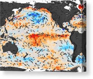 (Illustration out front: ‘El Niño Sea Temperatures,’ by NASA/Science Photo Library, and found here.)